


Field Topography UTM free
وصف لـField Topography UTM free
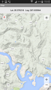
Topographical calculations for UTM & WGS84. Grid on the map.
Calculations in full or brief coordinates, in one or in the adjacent zones.
Rectangular coordinates in meters. Altitude, range in meters.
All angles on scale 64-00 or 60-00 (settings option on main screen).
In DGP and IGP angles are available in degrees - minutes – seconds.
GPS location in rectangular coordinates.
Azimuth of the Sun, the Polaris in specified time.
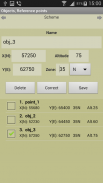
Maintain a list of objects that may be used in which the tasks (250). In free ver. - 3.
Read / write and append data from a file. The data file may edit/prepare a text editor, transfer methods available.
Google Maps, ArcGIS, MapBox, prepared ofline-atlases with markers points from the list (only with full coordinates).
Atlases in the format *.mbtiles can be created in SAS Planet, MobAC. Based on osmdroid.
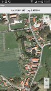
UTM-Grid on the map.
When you touch the marker shows the number and name of the point.
When you touch the map shown rectangular coordinates of the location.
Maps are cached (accumulated) to work without a network.
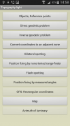
Tasks list:
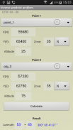
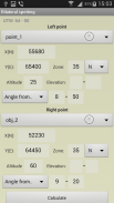
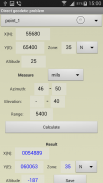
Direct geodetic problem;
Inverse geodetic problem;
Convert coordinates to an adjacent zone;
Localizing with paired observation (readout from the base or directions);;
Binding undirected rangefinder (range up to 2 known points);
Binding by measured angles(between the left-middle and middle-right known points with anchor points);
Binding according to GPS (geodetic and rectangular);
Azimuth of luminary;
Localizing with a stopwatch (with the air temperature);
Map.
Settings:
- Maps ( Google / ArcGIS / MapBox / prepared offline-atlases);
- The scale of thousandths (60-00 , 64-00)
- Color style
- The type of map (topographic, satellite, hybrid)
- Type of marker points on the map
- Grid on the map (no , 1km , 2 km )
- Save data to a file, read / write and append data from a file.
The program is distributed "as is". Its use - discretion and responsibility of the user.
All tasks and all the features available in the full version.
الحسابات الطبوغرافية لـ UTM & WGS84. الشبكة على الخريطة.
الحسابات بإحداثيات كاملة أو موجزة ، في واحد أو في المناطق المجاورة.
إحداثيات مستطيلة بالأمتار. الارتفاع ، مجموعة في متر.
جميع الزوايا على مقياس 64-00 أو 60-00 (خيار الإعدادات على الشاشة الرئيسية).
في زوايا DGP و IGP متوفرة بالدرجات - دقائق - ثانية.
موقع GPS في إحداثيات مستطيلة.
سمت الشمس ، بولاريس في الوقت المحدد.
الحفاظ على قائمة الكائنات التي يمكن استخدامها في المهام (250). في النسخة المجانية. - 3.
قراءة / كتابة وإلحاق البيانات من ملف. يجوز لملف البيانات تحرير / إعداد محرر نصوص ، ونقل الأساليب المتاحة.
خرائط Google ، ArcGIS ، MapBox ، أعدت أطلس الأطلس مع علامات علامات من القائمة (فقط مع الإحداثيات الكاملة).
يمكن إنشاء الأطالس بالتنسيق * .mbtiles في SAS Planet ، MobAC. بناء على osmdroid.
UTM-Grid على الخريطة.
عند لمس علامة يظهر رقم واسم هذه النقطة.
عند لمس الخريطة تظهر الإحداثيات مستطيلة من الموقع.
يتم تخزين الخرائط (المتراكمة) مؤقتًا للعمل بدون شبكة.
قائمة المهام:
مشكلة جيوديسية مباشرة
مشكلة جيوديسية معاكسة
تحويل الإحداثيات إلى منطقة مجاورة ؛
التعريب باستخدام الملاحظة المقترنة (قراءات من القاعدة أو الاتجاهات) ؛؛
ربط rangefinder غير موجه (نطاق يصل إلى 2 نقطة معروفة) ؛
الربط بواسطة الزوايا المقاسة (بين النقطتين الأيسرتين الوسطى واليمينية المعروفة بنقاط الربط) ؛
ملزمة وفقًا لنظام GPS (جيوديسي ومستطيل) ؛
سمت النجم ؛
التعريب باستخدام ساعة توقيت (مع درجة حرارة الهواء) ؛
خريطة.
الإعدادات:
- خرائط (Google / ArcGIS / MapBox / أطالس جاهزة دون اتصال بالإنترنت) ؛
- مقياس الألفيات (60-00 ، 64-00)
- نمط اللون
- نوع الخريطة (الطبوغرافية والأقمار الصناعية والهجين)
- نوع النقاط علامة على الخريطة
- الشبكة على الخريطة (لا ، 1 كم ، 2 كم)
- حفظ البيانات في ملف ، قراءة / كتابة وإلحاق البيانات من ملف.
يتم توزيع البرنامج "كما هو". استخدامه - السلطة التقديرية ومسؤولية المستخدم.
جميع المهام وجميع الميزات المتوفرة في النسخة الكاملة.
Field Topography UTM free - إصدار 2.8.1
(23-02-2022)Field Topography UTM free - معلومات APK
نُسخة APK: 2.8.1الحزمة: nordsoft.topoUTM_lightآخر إصدار من Field Topography UTM free
نُسخ أخرى


تطبيقات من الفئة نفسها


